Millcreek Canyon
Elevation Profile
Details
Probably my favorite.
Shaded by trees the whole way, not lots of traffic
(at least early in the morning), and a good workout at 8.5 miles.
Now that the road has been repaved above Elbow Fork, its even better
(especially coming down).
One of the hardest climbs is only half a mile from the fee station.
After that it is fairly flat until just before Elbow Fork where it offers
up a half mile of climbing that is as hard as anything in
Little Cottonwood.
The final mile is terraced much like the last mile of
City Creek,
only the climbs between flat stretches are longer.
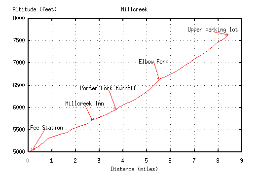
From the fee station to the upper parking area is
8.5 miles and 2600 vertical feet.
My P.R. is 62 minutes.
Measured Road Distances
Miles   Elev.  Landmark          Latitude, Longitude
0.0     5040   Fee station       40 41 22 N, 111 46 59 W
2.5     5720   Millcreek Inn
3.5     5950   Porter Fork
5.4     6630   Elbow Fork
8.5     7640   Upper parking lot 40 41 05 N, 111 40 23 W
Mike Hibler
<mike@cs.utah.edu>